.png)

3D Digital Terrain Flythrough
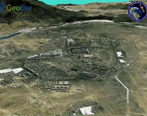
Satellite Imaging Corporation (SIC) produces clear, captivating simulated 3D digital terrain views of almost any location from high-resolution stereo satellite imagery. Our continuous worldwide exploration and resource mapping has allowed us to built one of the largest private satellite image data archives. We have the capability to produce the elevation data necessary to generate realistic and detailed perspectives for any of your project needs.
SIC can provide customers with <0.5m – 5m DSMs, DEMs, DTMs and a detailed, orthorectified stereo satellite image mosaic at <1m resolution to project planners, operation managers, and logistics managers to plan field operations in a computer environment, ensuring that the best access is provided and project objectives are achieved.
<1m Stereo IKONOS Satellite Map Data and 2m DSM
3D Flythrough of the Nuclear Facilities at Yongbyon (North Korea)
Click image to view 3D Flythrough Movie
Copyright © AIRBUS Defence & Space/processed by Satellite Image Corporation. All rights reserved.
3D digital terrain modeling and visualization application requires good detail pertaining to the terrain features and terrain slopes for critical project decisions, an accurate DSM must be available. If there is no suitable DSM available for the areas of interest (AOIs), then a DSM can be acquired by some of the following:
Stereo satellite image data
LiDAR (Light Detection and Ranging)
IFSAR (Interferometric Synthetic Aperture Radar)
Satellite sensors that provide stereo satellite imagery to support 3D Terrain Modeling and Visualization:

Consultancy
Ongoing Satellite remote sensing and GIS consultancy services are provided to our clients, including the set-up of reliable source coordinate databases in support of computerized mapping, exploration, and development of projects around the world and to clients implementing AI/ CV or GIS management systems, utilizing a variety of source data. For more information or for a consultation, please contact us.


.png)
.png)



FAQ’S